


Updated climate change sea level risk map shows large parts of Wales flooded by 2050
A special map has been produced to show the effect of climate change on the world of predicted rises in sea levels by 2050 – and it shows many Welsh cities and communities underwater.
The findings are based on a predicted global temperature rise of two degrees, and follow the IPCC report earlier this week which showed that a rise of 1.5C was now almost inevitable.
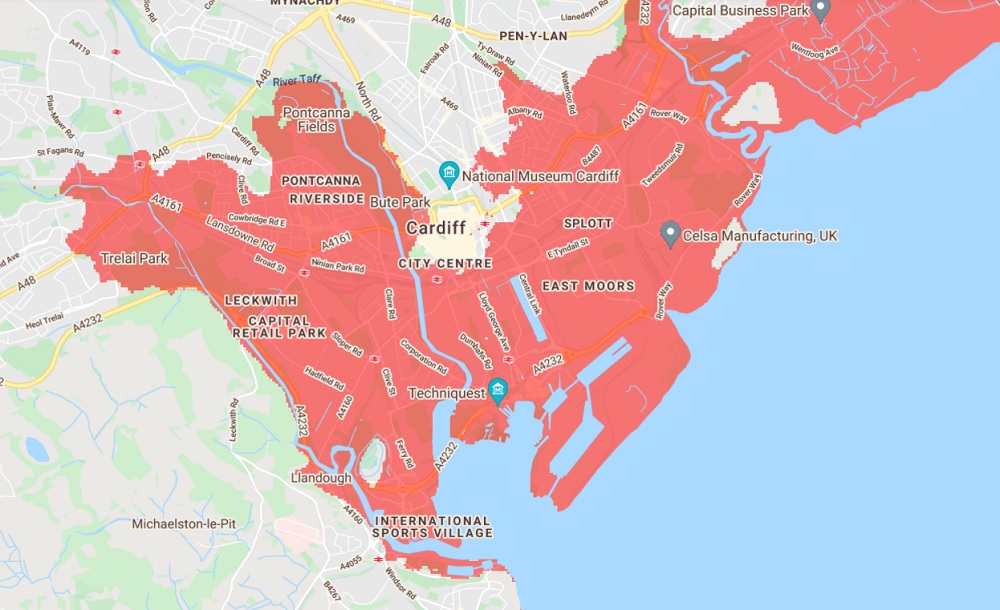
According to the recently updated map by Climate Central, a US-based climate science news and analysis firm, large parts of Cardiff, Newport and lower-lying parts of Swansea, Port Talbot could be hit by catastrophic flooding within the next 29 years.
In the north of Wales, Llandudno, Prestatyn, Rhyl, Shotton and Queensferry are vulnerable. Low-lying Borth and Ynyslas on the Ceredigion coast are also in danger, as well as Llandudno.
Llanbedr airfield could find itself submerged, and communities such as Machynlleth and Harlech could find the coast becoming much nearer. Pwllheli and coastal communities on Anglesey’s west coast are also set to find themselves in much greater danger of flooding.

Parts of Porthmadog and much of the land to the north, which was previously underwater before the building of the Cob, could also be reclaimed by the sea.

‘Code red’
Climate Central say they created an interactive map to show what areas are particularly under threat. The map allows users to explore coastal flood risk and sea level rise projections by decade for anywhere in the world.
The data is based on a scenario of moderate cuts to pollution, with even more areas covered in red if climate change continues unchecked. Climate Central said that they collated peer-reviewed data from scientific journals and plots it on an interactive world map.
They then combined this with additional datasets for elevation, tidal activity and the likelihood of coastal flooding.
The map comes after a Welsh Government commissioned poll published yesterday showed that only 15% of people in Wales believe that climate change will affect their local area ‘a great deal’.
According to results from a Welsh Government survey of 1,149 participants, fewer than half (42%) recognised that climate change could impact their local area to ‘some extent’.
However, an overwhelming majority (84%) believed that the way they lived their lives needed to substantially change to tackle the climate emergency, and 86% admitted they are concerned about climate change.
The results of the survey were published after a report by the UN’s Intergovernmental Panel on Climate Change found that a 1.5C rise in global temperatures was likely whatever efforts were now made to cut carbon emissions.
That would lead to extreme heatwaves, droughts, flooding and sea level rises, they said. UN Secretary General António Guterres said the repport was “code red” for humanity.
Support our Nation today
For the price of a cup of coffee a month you can help us create an independent, not-for-profit, national news service for the people of Wales, by the people of Wales.


Interesting. I live in Sully and using the scale at the side I notice little difference if any between the position in 2030 and 2050 2050. If this is correct why does your headline stress 2050 rather than earlier, assuming of course that the model is accurate?
You’re right. 2030 and 2050 seem to be identical around Borth/Dyfi valley.
I wonder if the key phrase is ‘land below annual flood level’ – i.e. NOT ‘below sea level’ – one really bad flood and those levels could already be reached, but they won’t be continuous.
At the moment I’m three miles from the coast. The 2050 map suggests I’ll be living on the beach!
South Road is at 20-30M above sea level so the sports fields will go first with Smithies Avenue and then the rise will slow. It will be all gone by 2100. The best illustration of the difference topography makes is to zoom out so Sully is on the right and Monknash on the left of your screen then shift a decade at a time. You sink, Monknash losses a beach. I strongly suspect that estuaries and rivers haven’t been properly accounted for and that the Taff will be tidal as far as the M4 at least. Check out where the… Read more »
I’ve tried fiddling with all the settings, good/bad luck, putting temperature in 2030 up by 4.8C… Nothing much seems to change. Some people would do this and say ‘all this global warming and things in 2090 aren’t any worse than 2030. Why do we need to change things?’ i.e. I find the map pretty useless in helping me decide on anything! I have relatives in Cardiff, near the river in the red zone, should I be advising them to sell up ASAP as 2030 is less than 9 years away? The map looks like a good reason to build that… Read more »
I would say yes, sell up now as their house will have no value once it is flooded! We cannot accturately predict how fast the sea will rise. Not even the best scientists with the best computers can do that as we do not know the speed of climate change. One thing is 100% sure — the sea is rising and there will be more flooding than ever in the history of this planet. We cannot stop this — we can only slow the rate of sea rise by being environmentally conscious, which at present we are not.
Always thought they should get rid of the Cob anyway and build a bridge instead.
Well-healed English tourists used to visit the area to view the reflection of Yr Wyddfa during the tide.
Presumably the ‘well-healed’ tourists had come to convalesce after accidents?
Well-heeled is the term.
Tell me : does the English living in your heads improve :
Failed paramilitary groups,
Failed arson groups, and a
Failed national independence movement.
See if you can’t give your country something more people are into before the William Prince of Wales crest gets designed.
The DDR misses you like a hole in the head.
The DDR would have dealt with 8 bungalow driveway pound shop Jac o’the North wannabes on a click bait website properly.
True the DDR would have employed far better agents provocateur than you, Eggy Fartz.
This website gets more hits than your Brittan Furst and EDL websites combined. And without Kermit Hitler, GBN would also be trailing NC
As I said
Hole in Head.
It’s the English living part-time in our HOUSES which are the problem Eggy. Not your
Failed attempts (500 years so far) to take over our nation
Failed attempts to end our Language
Failed attempts to rewrite history
Failed Brexit
Failed Empire
Don’t forget their failed (and corrupt) government.
Humanity has been talking about climate change for years if not decades and little has been done in reality. I suspect it is now too late sea levels will rise no matter what is done. So we need to prepare for events now, not after the sea level has risen. We either spend on defences or on big cleanups after the flooding has happened. Either way there will be vast amounts of money spent. So rather than the misery of flooded homes – we have to prepare – today !
My point on The Cob. Even if the “thing” does not happen, certain such steps can even be beneficial. But we need a committed independent government.
Please put the South Wales map up instead of America which is irrelevant. North Wales is in the body of the article but not the Dde.
But look on the bright side. All those people spending half a million quid on a lovely seaside ty haf – what a waste!
The shaded area of Cardiff seems to correspond to the area affected by the 1605 flood.Heaven help us if that were to happen again
Pretty much, but this time the flood will be less catastrophically sudden (good, it probably won’t directly kill anyone, unlike 1605), but won’t recede until global climate begins to cool again (not so good, economic disruption and deprivation will be considerable, and not just in Cardiff). The foreshore will move inland to approximately the current 10m contour line due to sea level rise, and the further inland still due to erosion and storm damage. The South Wales Main Line Railway will probably be the new shoreline, at least for a while.
Consider yourself lucky you don’t live in Taunton…
Looking at Aberystwyth is rather sobering. The flood area includes the Council emergency responce centre.
I did read that if the wind had been 15 degree more to the north in the floods a couple of years ago, Borth would have been rather wet. These are once every N year events rather than twice a day.
They are.
But N seems to be getting smaller.
London you will recall has had a flood barrage for decades. Perhaps tides find a different level in England.
In the first 10 years they used it 10 times. In the last ten they used it 79 times, 50 times in 2013/4 alone. It is approaching the end of it’s projected effective life.
Haven’t they let The Broads accept flood water now? Could do with an expert here.
2030 and 2050 give me the same map. Also although I’m near a river (Newport) my house is on a hill. I don’t think the map is very good on fine detail.
LOL. We’ve heard it all before. Fearmongering.
Sorry mate, we’ve past the scepticism point – the evidence is now overwhelming. People should not suffer due to ignorance.
Cantref Gwaelod!!
This kind of badly presented science does the case for urgent tackling of the climate no good. It is poor model and their admitted limitations outside specific parts the USA need more highlighting. They claim “peer reviewed” but do not publish their sources. The model seems to indicate that the inundation in 2030 would be equal to 2050. ???Climate change is serious – but opening up potential allegations of fake news is a dangerous strategy.
It should be noted we have been working on sea defences since the beginning of recorded history. For a more reasoned (but nonetheless worrying) review see https://www.climate.gov/news-features/understanding-climate/climate-change-global-sea-level
The maps in this article show ‘undefended’ views so could be construed as a little alarmist. Nevertheless, climate change is a real cause for concern at coastal locations.