
Action to be taken to restore right of way to forestry and mountains
Anthony Lewis, local democracy reporter
Action is set to be taken by a local authority to remove a gate which has been preventing public access to forestry and mountains.
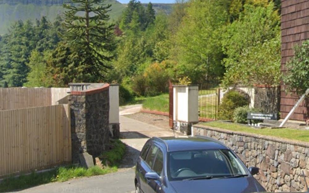
An Rhondda Cynon Taf officer decision has been taken to assert public rights of way over Vicarage Road in Cwmparc, where a gate has been installed without authorisation and to begin enforcement under the Highways Act 1980 for the removal of the obstruction and to re-establish lawful public access.
It’s been agreed a notice is served under the Highways Act on the landowners responsible for installing the obstructing gate, that the council asserts highway rights exist by virtue of more than 20 years of public use and officers are authorised to remove the obstruction and recover costs if the notice is not complied with.
The decision report said public access has been exercised freely and openly since the 1970s and there is strong local and national support for reinstating access.
Statutory duty
It said the council has a statutory duty to assert and protect the rights of the public to the use and enjoyment of the highway.
The route originated as an industrial incline and became an access route for the Forestry Commission in the early 1970s.
The land which the route uses was sold to a private owner in 1970.
The Forestry Commission enshrined access rights for itself as part of the 1970 sale of land, implying no dedication as a highway was intended at that stage, the report said.
It added it has been in uninterrupted public use by walkers, cyclists, and horse riders for more than 50 years.
The route is the only direct access from the community of Cwmparc to designated open access land and the report said Natural Resources Wales confirms its open and accepted public status.
The report said a locked gate was installed by new owners in February, preventing all access and they were of the view that no public rights exist over the route.
It said they state that when they bought the property, they were not informed of any potential access rights.
Anti-social behaviour
The report added the current owners state they have suffered persistent anti-social behaviour and they believe they have the right to protect themselves and their privacy.
The council report said: “Evidence collected includes statements from 18 individuals and organisations, historic mapping, digital route tracking.
“There is significant public sentiment regarding the re-establishment of this route evidenced by a petition totalling more than 4,000 signatories.”
In the summary of the argument supporting enforcement of highway rights, it said: “On balance, it is considered that Rhondda Cynon Taf County Borough Council should enforce highway rights at Vicarage Road, Cwmparc.
“This conclusion is supported by a substantial body of evidence demonstrating historic public use, legal precedent, and strong community interest.
“While the council acknowledges the concerns of the current property
owners, these do not outweigh the statutory duty placed upon the authority to assert and protect the rights of the public.”
Support our Nation today
For the price of a cup of coffee a month you can help us create an independent, not-for-profit, national news service for the people of Wales, by the people of Wales.


Seems that there has been a big access track there for a long time and anyone that bought land in the area would have been aware of that just by using their eyes. Closing a route traditionally used for access invites trouble. Ownership does not trump others rights
https://www.google.com/maps/search/cwmparc+gates/@51.6537625,-3.5194791,1057m/data=!3m1!1e3?authuser=0&entry=ttu&g_ep=EgoyMDI1MDQyMS4wIKXMDSoJLDEwMjExNjQwSAFQAw%3D%3D
OS maps on National Library of Scotland confirm the track was in place from at least 1965 from a revision of Sheet 154 1 inch to a mile map published in 1966
https://maps.nls.uk/view/197236850
I have maps showing that the path/ right of way was there in the 1890’s.
Hyn yn digwydd ledled Cymru. Pobl ddŵad o dros y clawdd (gan amled!) yn ceisio cau llwybrau cyhnoeddus yr hen werin bobl.
The photo in the article are not the gates in question thiese are
https://www.google.com/maps/@51.6537472,-3.5227375,3a,75y,90t/data=!3m8!1e2!3m6!1sCIABIhAGbzaqXxHFmmgI-CYABzwU!2e10!3e12!6shttps:%2F%2Flh3.googleusercontent.com%2Fgps-cs-s%2FAB5caB_bv5eQIJ8T6qBvAPkPeqLZ7503ncBZPaSzPNic9wW4QaF8pK0_n2j2NDHxHHZVaqsZH91oVEU9q6mFEOZQ8hcR09904idXjTchPohbe5l3lwrKbXrNwExiNV7VnWoXiMzchmTnGKSG5Mti%3Dw360-h270-k-no!7i4000!8i3000?authuser=0&entry=ttu&g_ep=EgoyMDI1MDQyMS4wIKXMDSoJLDEwMjExNjQwSAFQAw%3D%3D
Victory for common sense
If the current owners are unhappy they should raise it with whoever did the conveyancing when they bought it. Anyone doing the paperwork should really have considered this, the amount of research done when I bought my house over the status of a pathway and an old outside toilet(!) seems to have been better than they’ve had.