


Consultation launched on realignment of coastal road hit by flooding
Bruce Sinclair – Local democracy reporter
A public consultation has been launched on the first phase of a potential inland realignment of a Welsh seaside road which has been hit by heavy flooding.
The consultation is ahead of a formal Pembrokeshire County Council application to Pembrokeshire Coast National Park for Phase 1 of the Newgale Coastal Adaptation Project.
It would see the development of a new inland section of road with a bridge over Brandy Brook some 2.3km inland, to replace the coastal section of A487 at Newgale that will be closed and removed, and corresponding reclassification of Newgale Hill and Wood Hill coupled with local access improvements within Newgale.
These will comprise a short access road to existing beach front commercial properties, to be in place for up to ten years, bus stop provisions and turning facilities, and a traffic-free Shared Use Path that will replace part of the Wales Coast Path.
Storms
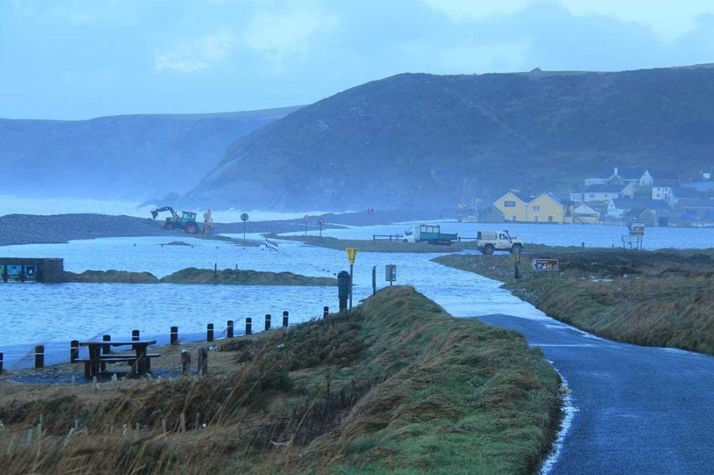
Newgale was hit hard by flooding following storms in early 2014 storms, and later by Storm Dennis in 2020.
In 2014 it even saw a visit by the-then Prime Minister David Cameron, as part of a tour of the UK to “learn lessons” following storms and flooding that year.
The main A487 road was closed for about 14 days after waves breached pebble defences that year, and a Richards Bros bus was stranded in floodwater after it was hit by a high wave, leading to the rescue of around 10 passengers.
In 2018, Pembrokeshire County Council’s Cabinet backed a recommendation, long-term, for an inland highway link for the A487.
Shoreline
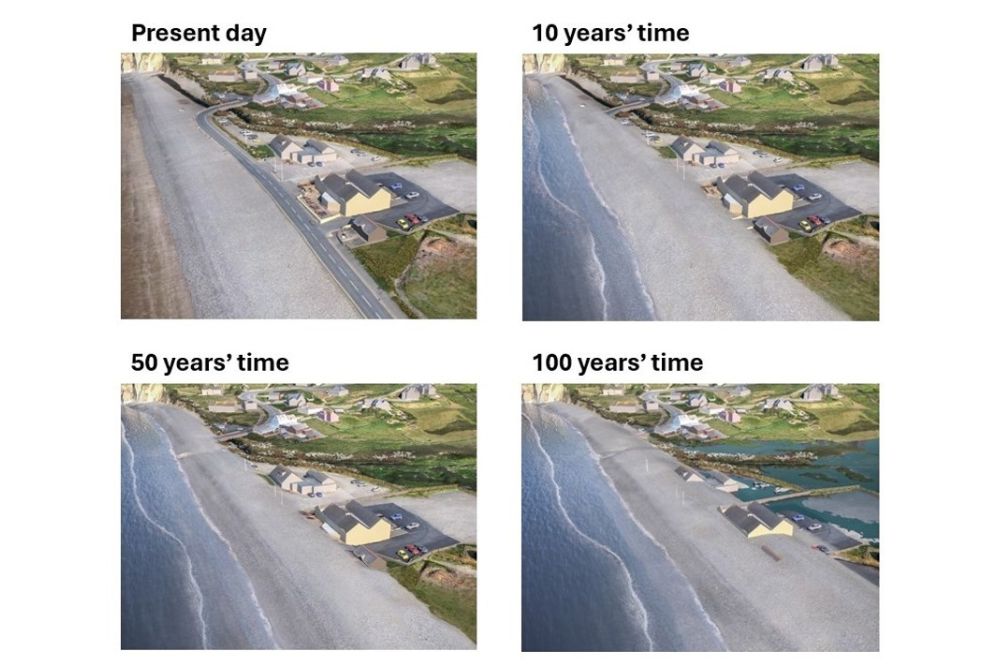
A supporting statement through agent AtkinsRéalis says the recommended strategic coastal management policy for Newgale is ‘managed realignment,’ allowing the coastline to move backwards and retreat inland, but with management to control the movement, the shoreline management plan recommending that a policy of ‘no active intervention’ is implemented from 2055, meaning no investment in coastal defence or operations.
The Phase 1 proposals comprise of: Rerouting the Newgale section of the A487 main St Davids to Haverfordwest road. Creating a new walking and cycling path through Newgale. Changing access to the beach and coastal businesses. Releasing space for the beach to adapt to coastal change.
The statement adds: “The village of Newgale and the adjacent coastal stretch of the A487 are affected by flooding from waves overtopping the shingle ridge. During storm events, high waves throw shingle onto the road, which can cause flooding of the land behind. Shingle that has landed on the road, blocks access and causes temporary closure of the road until it can be cleared. The road is maintained by shingle clearance on a regular basis, and during periods when the road has to be closed, this causes significant traffic disruption.”
It says a 2020 report commissioned by Pembrokeshire County Council into coastal change at Newgale concluded “that continued efforts to maintain the shingle ridge as a defence is highly likely to be unsustainable beyond 2035, more realistically by 2030,” adding: “Early action is required before the road becomes impassable and unsafe.”
The phase 1 scheme is part of a possible wider Newgale Coastal Adaptation Project, with many other potential future works.
An alternative approach, the Newgale Beach Shingle Bank Realignment Scheme (NSBRS) scheme, by Stand Up for Newgale (STUN), had proposed a section of the shingle bank at Newgale be realigned 10-12 metres to the seaward leaving an over wash barrier between it and the A487 to capture any pebbles and sea water.
The Pembrokeshire County Council proposals have been previously costed at £20m, with some raising that as high as £40m now, with consultation costs alone to date said to be some £2m.
The Pre-application Consultation runs until May 11, with plans available online; comments may be sent to [email protected] or by post: Newgale Coastal Adaptation Project Team, AtkinsRéalis, Floor 4, West Glamorgan House, 12 Orchard Street, Swansea, SA1 5AD.
Support our Nation today
For the price of a cup of coffee a month you can help us create an independent, not-for-profit, national news service for the people of Wales, by the people of Wales.


Rising seas, write it off.
The sand beach in front only has a slope of say 1:200, rising 1metre over 200 metres sea level only has to rise say 50 centimeters (1/2 metre) and the beach and the storm beach then wants to move 100 metres inland.
You cannot move the storm beach seawards without losing the sand.
You can see that in Aberystwyth at the northern end of the Prom. The Victorians stole the beach and now it has gone replaced by massive boulders to protect the property.
Not just that, storms getting more energy and frequent. There are places where the best policy will be relocation (long term cost vs short term fail). Or you are just build walls(shingle banks, stones, whatever) a tad higher each year and crossing fingers.
Pembrokeshire council starts it all off as cost escalate (consultation costs alone to date said to be some £2m, This will no doubt go up and up and up. Why no one will be able to say.) But then they must get the money from government (unless they use their reserves ) and this government will definitely say no especially with their no new roads policy. Now you’ve got your answer as Welsh Labour Government use consultations in a way of saying non.