


RCT Council to consider final works to stabilise Tylorstown tip
Anthony Lewis – Local Democracy Service
Rhondda Cynon Taf Council is to consider planning applications for the final phases of work to stabilise the Tylorstown tip following a landslide at the site during Storm Dennis.
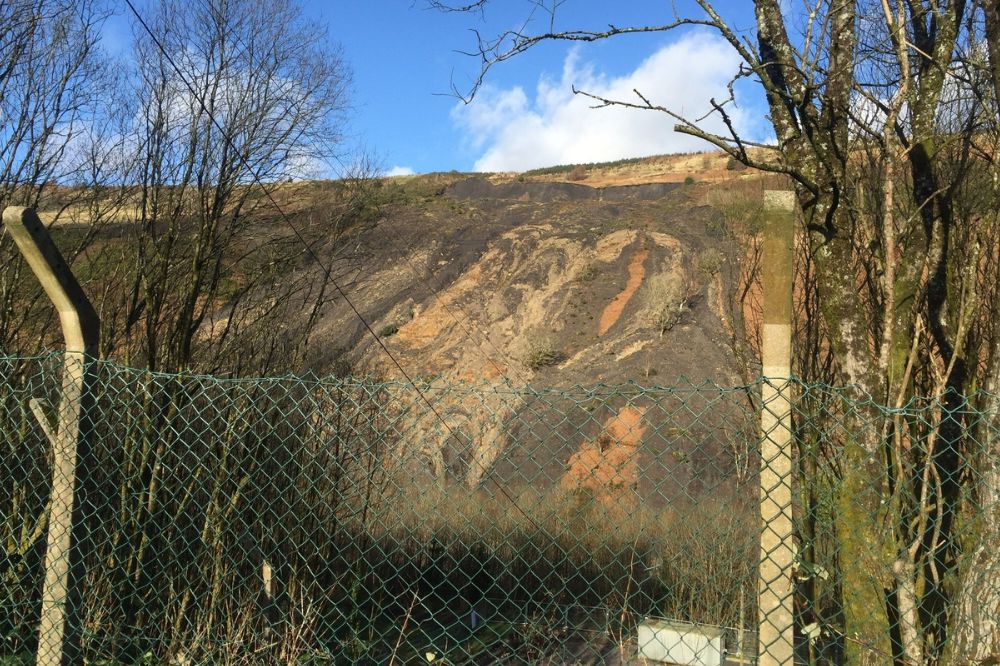
Around 60,000 cubic metres of material at the former coal tip slid down the mountain in February 2020 after three successive storms.
The landslide on Llanwonno hillside blocked the river valley, broke a foul sewer, covered a water main with several metres of debris, and covered a footpath and cycle path and the area was immediately closed to members of the public for safety reasons.
Over the three years since Storm Dennis, four phases of work have been carried out to ensure the site is made safe.
On Thursday (August 17) Rhondda Cynon Taf Council’s planning committee will consider more applications related to the works.
One involves the permanent retention of a land form created by a deposit of approximately 19,700 cubic metres of material from the Tylorstown landslip at land across from Oaklands Business Park in Ferndale which would include the planting of trees.
Another planning application would involve the permanent retention of approximately 740 cubic metres of material from the landslip on land to the south of Station Road in Ferndale including proposed benches and small footbridges
Monitoring
Storm Dennis was a one in 200-year storm event that saw Maerdy at the top of the Rhondda Fach record the highest volume of rainfall in Wales.
The site is a Category D tip and was being inspected every three months against a set of monitoring criteria prior to the storm, and inspections have subsequently increased in frequency since.
The first phase of the works involved emergency drainage and vegetation clearance and this was done in the weeks following the storm.
The second phase involved embankment scour repairs which started in late June 2020 and was finished in June 2021.
Phase three involved the moving of material to receptor sites and temporary reinstatement of paths which started in late June 2020 and was finished in June 2021.
An additional phase of work to stabilise the slope above the one remaining closed footpath was completed in the autumn of 2021.
Phases two and three were estimated to cost £2.5m and meant that the slipped material had now been removed from the valley floor, the river had been reinstated to its correct line and level and a series of drainage works had been done.
It also allowed the two walking and cycling routes on the leisure centre side of the river to reopen.
The third route running through the area, on the opposite side of the river, has been repaired but has remained closed as there are future phases of work to stabilise the hillside above.
While the closure area for this path is around 1.5km, the wider route it forms a part of is open and can be accessed from Station Road in Ferndale and the council intends to reopen all routes in the future.
The three receptor sites are owned by Rhondda Cynon Taf Council and are located to the north of the landslip site, alongside the former railway line.
Receptor Site B (nearest the landslip site) formed part of the old railway sidings, and receptor Site A1 and A2 was a former colliery site footprint.
Planning permission for the receptor sites (temporary) for the slip material was subsequently applied for retrospectively, and it was granted by the planning committee on Thursday, January 21, 2021.
The council says that placing the spoil material on these sites has significantly reduced the amount of material which would have otherwise be moved along the public highway.
The receptor sites have also ensured that the wider works are self-contained – and therefore the carbon footprint of the works is greatly reduced as there have been virtually no vehicles on the public highway from the site, which would otherwise cause noise, vibrations, air pollution, dust and damage to the carriageway.
It is estimated that the process of moving 60,000 tonnes of material would have required 6,000 lorry movements – which the council said was avoided by utilising the receptor sites.
The council says there will be the opportunity for residents to have their say in the final end use through a future consultation process.
Drainage
At present, the council is considering the location to be converted into a riverside walkway and bike use area, similar to the existing sites at Barry Sidings Country Park and Mountain Ash Riverside Park.
Phase four involves the remediation of the remaining tip on the hillside with more than £10m going towards this.
Upon completion of the remediation works, an active travel community route for pedestrians and cyclists between Maerdy and Pontygwaith can then be delivered, subject to Welsh Government funding and it would pass through the riverside park scheme at Tylorstown.
Planning permission for phase four was granted in October 2022 and works started on site in April 2023 and it will enable future enhancements to the community route.
It involves relocating colliery material to a site adjacent to the tip, and stabilising the upper tip site.
It also includes new drainage work, the formation of access tracks and paths and vegetation.
There are also planned improvement works to several structures along the proposed community route in the future with it being resurfaced and works to the receptor sites completed.
A number of surveys have been done by consultant ecologists in liaison with the council’s ecologist and Natural Resources Wales around the clearance of undergrowth and trees from the receptor sites – together with the impact on flora and fauna.
The council says that all parties continue to work together to ensure the impact on the environment is minimised where possible.
It adds that consideration is being given to the final receptor sites and how this will benefit the ecology of the river valley.
Support our Nation today
For the price of a cup of coffee a month you can help us create an independent, not-for-profit, national news service for the people of Wales, by the people of Wales.
Get more trusted Welsh news
Choose Nation.Cymru as a preferred source in Google News to see more of our journalism.


As this was a National Coal Board waste tip, surely the cost should be borne by Westminster, not RCT residents, after all, the profit from the industry all went into the Treasury.
Senedd, take note of this before rushing into more nuclear power stations, modular or otherwise, as we Cymru will be expected to bear the staggering costs of dismantling and waste containment in the future.
Exactly what I was thinking. No mention is made in this report if the cost of this work is being 100% paid for by the people who profited from it or if the responsible party has been approached by the council. Not a penny should be paid by the local taxpayer. The Cymry have already been robbed out of £6bn. compensation for HS2. Wake up in the Senedd for goodness sake. They need a bloody good shaking for allowing Cymru to be walked over. Fight man, fight for our rights!!!
Also, adding to my comment above, who has been awarded the contract to clear the site? Hopefully it is a Welsh company so that the money stays here in Wales. Too many contracts are being awarded to cross-border contractors probably because of lack of investment, training and apprenticeships by the WG and Westminster to build up a professional and skillful workforce here. If that was done Welsh companies could benefit from outside contracts. It’s the same old story here….. keep them thick, poor and wanting.