Scenic housing estate plans given go-ahead despite flooding fears

Twm Owen, local democracy reporter
A housing estate that will be laid out to ensure a historic castle will remain in view has been given the go-ahead despite flooding fears.
Councillors approved the plans for 21 new houses on a field beside the main road through Raglan just over a week after the village was hit by flooding caused by Storm Bert.
Flooding
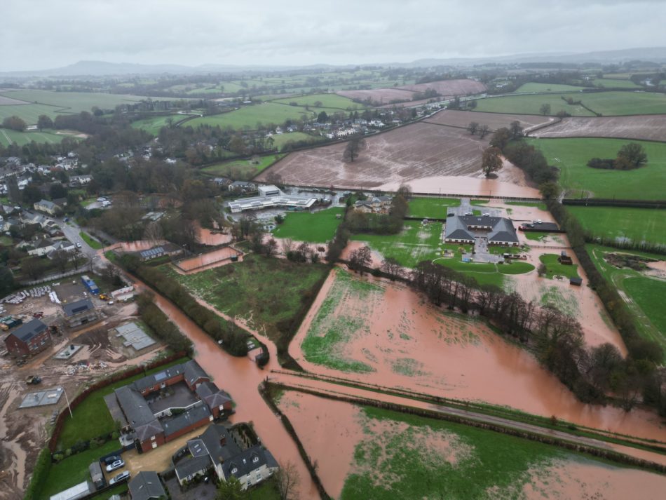
An aerial photograph shows the extent of the flooding with parts of Chepstow Road, and a new housing development currently under construction beside it, underwater as well as the southern end of a field directly opposite the approved site, which has been earmarked for 54 new houses.
Welsh Water’s waste water treatment works in the village were also hit by groundwater flooding, but the firm confirmed it hadn’t impacted its operation.
Monmouthshire County Council’s flood officer made no objection as the field, on the northern side of Monmouth Road, isn’t considered at risk of any type of flooding according to Natural Resources Wales mapping and there is no record of flooding close to the site.
Among the 19 objections received from members of the public were concerns over surface water drainage, and councillors also raised its potential impact.
Mitchell Troy and Trellech member Jayne McKenna said she was concerned at the potential of surface water overwhelming the nearby Barton Brook, with it proposed it will be discharged to, while Usk member Meirion Howells said he feared homes to the north could be at increased risk of flooding.
Satisfied
Planning officer Andrew Jones said the risk of flooding to third party properties is considered, and he said the council’s sustainable drainage department is satisfied with the proposals, though a separate application will still have to be approved.
Raglan councillor Penny Jones raised surface water and the impact of traffic and said the site, although privately owned, is listed in the council’s current development plan as an area of amenity open space within the village conservation area.
She said: “We must remember the historic significance of Raglan and its reliance on tourism, and it is a conservation area.”
A report said housing can be permitted in amenity areas, a designation it is proposed would be removed in the council’s replacement development plan, and Mr Jones said the estate has been designed with the housing in rows to preserve views of Raglan Castle. There will be a public viewing area and bench, with unrestricted access, at the northern end of the site, though there are currently no rights of way through the field.
Application
As a result of the application process, developers Edenstone Homes reduced the number of properties to 21 from 23 as well as the mix of sizes and their location to preserve the views of the castle.
In line with the council’s current policy seven homes, which is 35 per cent, will be affordable for social rent and shared ownership with a mix of one and two bedrooms properties and one three-bedroom house. All the open market housing will be four bedroom homes.
Goytre Fawr councillor Jan Butler complained developers aren’t building smaller homes, which she said are needed in Monmouthshire.
The developers will also have to make a contribution, under a section 106 legal agreement, towards the maintenance of public footpaths and play equipment while they will also extend the pavement along the front of the development site.
Support our Nation today
For the price of a cup of coffee a month you can help us create an independent, not-for-profit, national news service for the people of Wales, by the people of Wales.


Must be nuts to build on vulnerable land. Council daft to grant planning permission. Public daft if they ever buy there.
OK, but make the developer entirely responsible for any and all flood defenses and future flood relief.
They are building on a flood plain – the clue is in the name.
This is the sort of development which should not happen. It’s flooding now and over the years ahead flooding will only get worse.
Poorly worded article. The site under consideration isn’t in the floodplain and is towards the top centre of the photo, not in or near the flooded area.