


Storm Agnes ‘intensifying quickly’ as Wales braced for damaging winds
Storm Agnes is “intensifying quickly” and will hit the UK and Ireland with damaging winds and big stormy seas, the Met Office has said.
It issued a string of weather warnings ahead of the arrival of the first named storm of the season on Wednesday.
It is expected to generate winds of up to 75mph and cause dangerous conditions along coastlines, especially Irish Sea coastlines.
Meteorologist Tom Morgan told the PA news agency: “Storm Agnes is now very much intensifying quickly about 1,000 miles or so away from the south-west of England, in the Atlantic Ocean, and it’s moving quickly north-eastwards towards the UK.”
He said the storm’s main impact will be strong winds and large waves.
“We are likely to potentially see some damaging winds, the possibility of some brief power interruptions, particularly in Irish sea coastal areas,” Mr Morgan told PA.
“So Northern Ireland, north-west England, west Wales, and south-west Scotland, that’s where we’ll probably see gusts of up to 75mph tomorrow afternoon, tomorrow evening, that’s when the peak of the winds will be and then Storm Agnes will move across Scotland clearing away from Shetland through Thursday morning.”
He added: “In addition to the winds, there’s going to be some large waves as well, so some big stormy seas, and therefore there might well be some coastal flooding where the waves break on to promenades and on to coastal roads.”
The storm will make landfall on the west coast of Ireland and winds will start to pick up for the UK around midday.
He warned of potential disruption to ferry services across the Irish Sea, bridge closures, power cuts and “small amounts” of damage to buildings.
Dangerous
He described Storm Agnes as “more widespread” than the last named storm to hit the UK – Storm Betty – but said it will not produce “significant widespread and long lasting travel disruption”.
By Thursday, most parts of the UK are poised for a “much calmer” forecast and further spells of wet and breezy weather should peter out by the end of the week for a drier weekend.
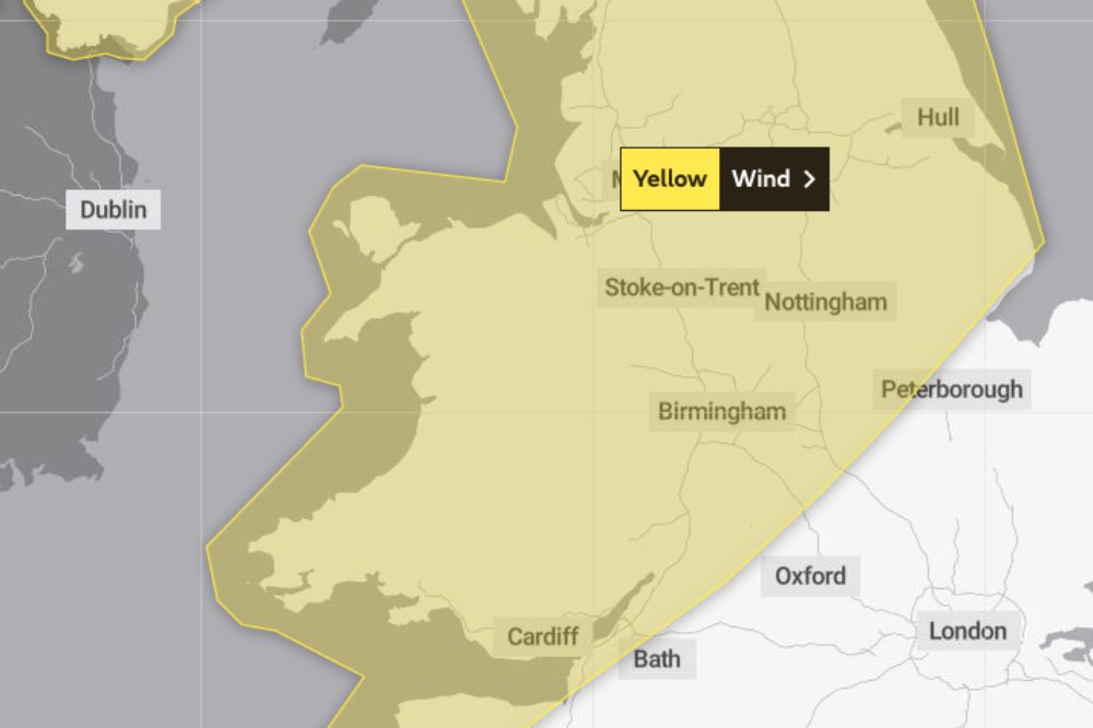
Warnings include a yellow wind weather warning from midday on Wednesday to 7am on Thursday, stretching across Scotland, Northern Ireland and Wales, as well as the south-west of England, the West Midlands and most of the north of England.
Two yellow rain warnings will also be in place covering areas of Scotland between 3pm on Wednesday through to midnight – one in central Scotland, from the north of Glasgow across towards Aberdeen, and another in the far south-west of Scotland.
The Royal National Lifeboat Institution (RNLI) said the storm is likely to cause “dangerous conditions” on the coasts around the UK and Ireland.
RNLI water safety partner Sam Hughes said: “The RNLI advises staying a safe distance away from the water and cliff edges as the conditions could knock you off your feet or wash you into the sea. It is not worth risking your life.
“If you see someone else in danger in the water, call 999 or 112 and ask for the Coastguard. If you have something that floats that they can hold on to, throw it to them. Don’t go in the water yourself – you may end up in difficulty too.”
Support our Nation today
For the price of a cup of coffee a month you can help us create an independent, not-for-profit, national news service for the people of Wales, by the people of Wales.
Get more trusted Welsh news
Choose Nation.Cymru as a preferred source in Google News to see more of our journalism.


