Storm Ciarán to bring yellow and amber weather alerts to Wales

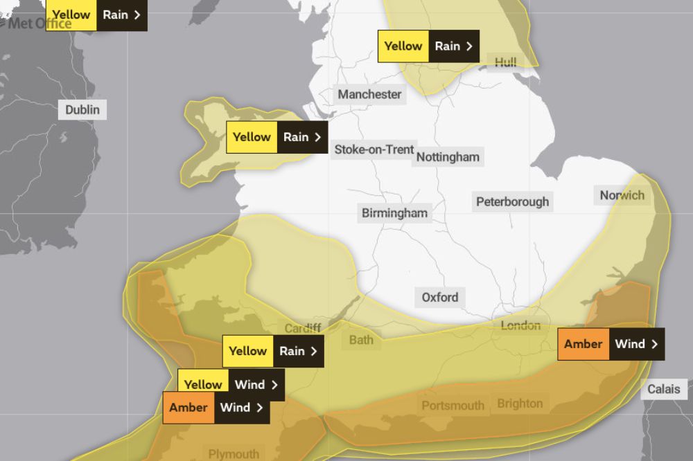
Much of the country is bracing itself for wind and heavy rain with Storm Ciarán bringing yellow and amber alerts from Wednesday.
Amber warnings are in place for parts of Pembrokeshire on Thursday when Storm Ciarán is due to hit, together with further yellow rain warnings.
The storm has already caused flooding in Northern Ireland, where a yellow rain warning from the Met Office is in place until 9am on Wednesday.
A similar notice has been issued for southern parts of Wales from 6pm on Wednesday until the end of Thursday.
A further yellow warning for wind has also been issued for parts of south Wales from 6pm on Wednesday and throughout Thursday.
Met Office deputy chief meteorologist Dan Suri said a cold front would bring bursts of heavy rain and coastal gusts of 60 to 70mph along the south coast on Wednesday.
He said: “Wind and rain warnings associated with Storm Ciarán are in force from Wednesday night onwards into Friday.
“As well as strong winds, this deep low pressure system will bring heavy rain to many parts of the UK.
“Much of southern England and south Wales, as well as parts of north Wales, northeast England, southeast Scotland and perhaps the east of Northern Ireland look to see the wettest conditions between Wednesday evening and Friday morning.”
He said 20 to 25mm of rain may fall in many places with 40 to 60mm possible over higher ground.
“Some parts of south Wales and southwest England may see 80mm of rain,” he said. “This rain will fall on already saturated ground, bringing the risk of flooding.”
Thursday’s amber warning is in place from 3am to 1pm on the extreme west coast of Pembrokeshire on Thursday, with the Met Office predicting Storm Ciarán will bring winds of 75 to 85mph with 65 to 75mph gusts inland.
The warning says wind could disrupt travel, power lines and cause structural damage with flying debris providing a threat to life.
Flooding
Elsewhere in southwest Wales, gusts could reach 50 to 60mph with 60 to 70mph on the coasts.
Kate Marks, flood duty manager at the Environment Agency said “significant flooding” is possible.
She said: “We advise people to stay away from swollen rivers and urge people not to drive through flood water as just 30cm of flowing water is enough to move your car.”
Natural Resources Wales has issued 13 flood alerts.
The weather is not showing much sign of a rapid improvement once Storm Ciarán does pass.
Met Office deputy chief meteorologist Steven Keates said: “Once Storm Ciarán has passed, the weather over the weekend continues to look unsettled for many with more showers and rain at times.
“Warnings will continue to be updated over the coming days, so it is important to stay up to date with the Met Office forecast and warnings in your area.”
Support our Nation today
For the price of a cup of coffee a month you can help us create an independent, not-for-profit, national news service for the people of Wales, by the people of Wales.


France has issued red weather warnings for this, of course depends where it hits. No one should be messing around with this.
Is this another storm in our teacup? The news media love to announce these dire warnings about our weather, causing panic, disruptions and empty supermarket shelves, all based on “possibilities” issued by the Met Office. Why? Because bad news is sensationalism and sells newspapers. Yes, it is better to err on the side of caution, better to be safe than sorry, Keep an eye on Met Office forecasts, in particular note the constantly changing wind direction. Let’s hope that this latest storm to cross the Atlantic will fizzle into drizzle over most of Wales, as have so many in the… Read more »
I tend to check in with the experts. The track of this decides how bad. Someone is going to get it.
Other weather sources are available.
https://www.netweather.tv/weather-forecasts/news/12212-stay-at-home-on-thursday—channel-islands-and-northern-france-in-storm-ciaran