


Why more flood defences may not save Fairbourne from rising sea levels
Sophie Ward, Research Fellow in Physical Oceanography, Bangor University, Martin Austin, Senior Lecturer in Coastal Dynamics, Bangor University
The impact of rising sea levels on our coastlines can be profound. A natural shoreline can respond to sea level rise and coastal erosion, provided the rise isn’t too rapid.
Given enough time, flora and fauna may have a chance to adapt. But a coastal area which has been heavily developed will respond differently, sometimes with catastrophic impacts on both people and nature.
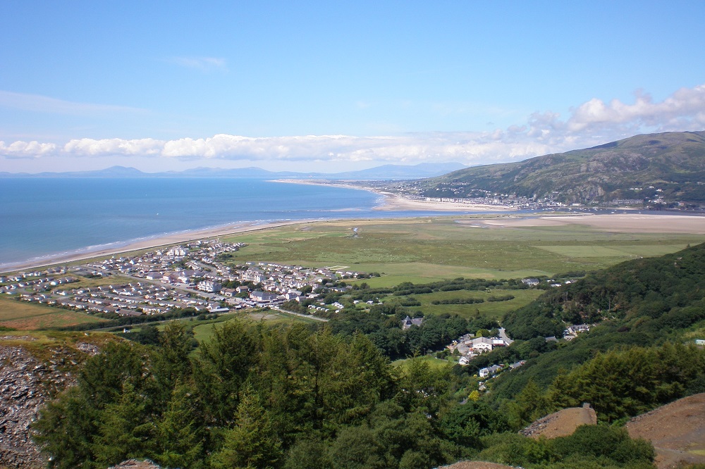
Fairbourne is a small village on the west coast of Wales and is the first place in the UK to have been assigned the long-term policy of “no active intervention” regarding its coastal defences. That is when a decision is made not to invest in providing or maintaining sea defences.
This has led to Fairbourne’s inhabitants being described as “the UK’s first climate change refugees” by news media.
In the UK, regional shoreline management plans (SMPs) are developed for managing coastlines from flood and erosion risk. SMPs consider the potential risks and select from a range of options, consisting of building new sea defences, through to the aforementioned “no active intervention”.
In Fairbourne’s case, the SMP suggests it will neither be safe nor sustainable to remain in the village by around 2054. The intention is for the authorities to monitor and maintain the existing coastal defences in the short and medium term.
On @itvnews shortly, the "climate refugees" who refuse the tag and are fighting back.
Gwynedd Council appears to be rowing back on a plan to "decommission" Fairbourne by 2054 due to rising sea levels.
But residents say the policy shambles was "crass and cruel" #Fairbourne pic.twitter.com/XbTgWxOr0D
— Rhys Williams﮷ (@RhysWilliamsTV) January 30, 2023
Ultimately, the village may be decommissioned, although details are scant on what that means. It remains a contentious issue and the community continues to fight for increased support from government organisations.
At the turn of the 20th century, Fairbourne was just a cluster of houses on the Gwynedd coast at the mouth of the Mawddach estuary. Over the past 100 years, the village has expanded to around 460 properties. It has around 700 inhabitants and is popular with tourists.
Fairbourne is built on a low-lying floodplain. The village lies between cliffs and a natural gravel barrier which houses a sea wall, and is at risk from both coastal and river flooding. As the sea level around the Welsh coast rises, the village is at increased risk from coastal flooding.
Sea level rise drivers
There are two main factors which drive global mean sea level rise, both related to climate change. First, the addition of freshwater to our oceans from melting glaciers and ice sheets. And second, the expansion of ocean water as it warms up, which is a consequence of higher atmospheric temperatures.
The global mean sea level rose higher in the 20th century than in any other century during the last 3,000 years. The rate of global mean sea level rise in 2021 was the highest ever recorded. Uncertainty remains in the projections of future sea level rise but the latest estimate is that a global rise of up to approximately 1 metre by 2100 is possible.
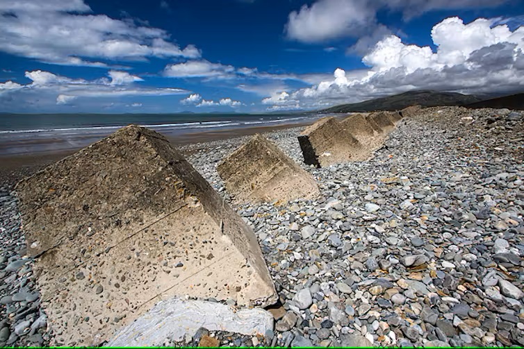
The response of a natural gravel barrier coastline to sea level rise is mainly controlled by the amount of nearby sediment and the rate at which the sea level is rising along that section of coast.
Where there is available mobile sediment, a barrier will move towards the land under rising sea levels. This process is called “roll-over”, as sediments are pushed up and over the crest of the barrier towards the land.
However, if the barrier is prevented from moving or if the sea level rises rapidly, more significant structural changes can happen. First, the barrier tends to get steeper, which then promotes more energetic wave breaking.
In time, the barrier crest becomes vulnerable which can lead to it being breached. In the case of Fairbourne, which is behind such a barrier, a breach could result in the village being flooded.
Second, the barrier needs time to adapt to changes in sea level. When the level of the sea rises rapidly, the barrier cannot evolve quickly enough to keep up.
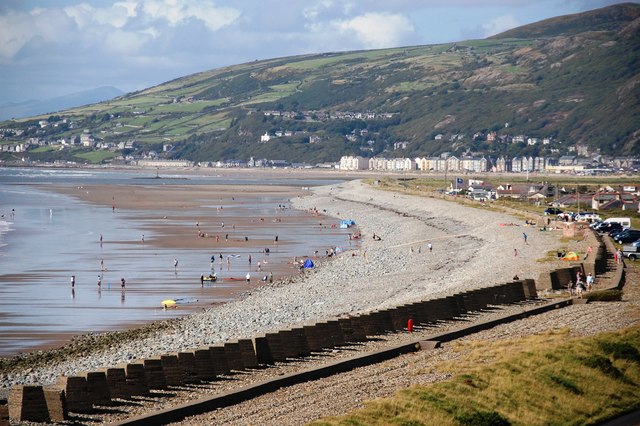
Photo by SMJ is licensed under CC BY-SA 2.0.
In Fairbourne, these factors combine to increase the flood risk to the community. The sediment supply to the gravel barrier is limited. To compound the issue, as the sea level rises, the water becomes deeper which leads to less available wave energy for pushing sediments onshore.
The potential for Fairbourne’s seaward barrier to shift towards the land is limited by the lack of space. The barrier is somewhat trapped between the hard rock of the cliffs and the nearby Afon Mawddach.
What’s more, the existing seawall fixes the crest of the barrier in place and therefore increases its vulnerability. Meanwhile, the sea level continues to rise.
Adaptation
Physical and environmental factors aside, sea level rise is a complicated socio-economic issue. Regardless of the financial cost, building coastal defences is not always the best method of adaptation.
The UK’s SMPs provide a strategic approach to coastal management and defence. However, retreating from the coastline, disbanding communities, abandoning homes and decommissioning villages such as Fairbourne really is the ultimate form of adaptation and so requires careful consideration.
Given around 10% of the world’s population live in coastal areas fewer than 10 metres above sea level, this is a topic we’re likely to be discussing a lot more in years to come.
This article was first published on The Coversation
![]()
Support our Nation today
For the price of a cup of coffee a month you can help us create an independent, not-for-profit, national news service for the people of Wales, by the people of Wales.
Get more trusted Welsh news
Choose Nation.Cymru as a preferred source in Google News to see more of our journalism.


A very rough check of the topographic map of Fairbourne and the Mawddach estuary led me to believe that to protect the homes there would necessitate the building of a sea wall 90 miles or more long. Otherwise the tide would just flow around the sides. It is already below high tide levels.
This gradualist description is obviously wrong where storm surges are dominant in re-shaping the coast and flooding inland. The occasional major surges are crucial. This article fails to even mention increasing ferocity of storms under climate change. How far are our Shoreline Management Plans unreliable because of the in-built gradualism?
Fairbourne Marina and Wetlands Reserve…Millions live on houseboats/sampans already…
The authors of this article appear to have a poor understanding of the coastal processes operating in Fairbourne along the Ro-Wen shingle spit. A number of years of detailed surveying by Professor M. Phillips of University of Wales, Lampeter have shown that the spit can be divided into three zones. In the central zone in front of Fairbourne village, the profile of the spit is very stable and no roll-over is occurring. North of the village, the spit is accumulating shingle and increasing in width. Only several miles to the south near Friog is a slight loss of shingle occurring, but it is unlikely… Read more »
To match sea level rise, we need the spit to accumulate shingle, as has happened slowly over decades (and centuries). Are there ways to assist this as done historically – via rows of wooden groynes?
I don’t recall any idea of such low-cost working-with-nature in the Shoreline Management Plan.
Tra mor yn fur i’r bur hoff bau O bydded i’r heniaith barhau. Ynte bobl Fairbourne – da iawn.