
Bid to relocate popular supermarket refused by council
Dale Spridgeon, Local Democracy Reporter
Plans to move popular Co-op store to new site rejected over countryside and flooding concerns.
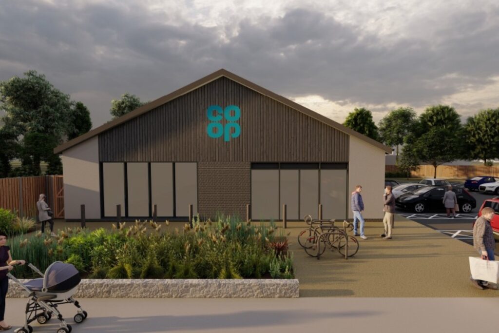
Cyngor Gwynedd planners turned down a scheme proposed on land north of Plastirion Terrace on the A4086, amid concerns over its location and flooding.
The plan for a purpose-built single-storey convenience store, associated parking and access was made by Thistlewood Properties through the agent Murshed Ahmed of Edgeplan Ltd.
The site lay within the established settlement of Llanrug, and was surrounded by housing, commercial and community buildings.
The plans said it was intended to relocate the existing Co-op currently operating on nearby Station Road.
The report stated: “The existing premises are constrained in terms of size and condition making it difficult to meet modern operational requirements.
“The current store also lacks off-street parking. As Station Road is relatively narrow, when customer cars are parked in front of the store, the remaining carriageway width allows only one vehicle to pass at a time, leading to congestion and conflict between opposing traffic.
“Delivery vehicles also block Station Road to an even greater extent and require goods to be carried on trolleys across the pedestrian footpath.
“This not only interferes with the safe passage of customers and other pedestrians, but involves a step-up to cross the kerb – meaning that specialist equipment is required.
“The proposed development provides an opportunity to relocate the store to a more suitable site within the same settlement, addressing these operational and highway issues while providing adequate parking and servicing arrangements and maintaining local access to essential retail services.
Vegetation
A green infrastructure statement had described the site as “currently poor semi-improved grassland, bare ground, marshy grassland and bordered to the east by a stream and coniferous trees (and one broadleaved tree).
“The stream runs from south to north along the eastern boundary of the site. Parts of the site were quite waterlogged at the time of the survey.”
It had noted the land had been previously developed but had “become vegetated”.
Japanese Knotweed had also been identified in the rubble/earth pile to the west of the site during a a reptile survey, it said.
The invasive non-native species (INNS) had “not been visible during a survey for a pre-ecological assessment (PEA) in February and had not been included within that document”.
No reptiles were found, the area was believed to be “unsuitable” for great crested newts, although measures were recommended to avoid damage to biodiversity, habitats and species.
A site-specific flood consequences assessment for the applicant had noted the site was within Flood Zone 1 (in NRW mapping details) and the north-east part of the site within Flood Zones 2 and 3, from surface water and small watercourses related to the adjacent Afon Rhos.
However, it was stated, it was “a less vulnerable development” and that issues would be managed post development and with “raised site levels and increased capacity of the watercourse “which will reduce the risk.
“The proposed building will be located at a low-risk area” and associated flood risks from groundwater was also “expected to be low during the dry months and medium during the wet months”.
Open countryside
In their decision, planners had stated the development’s location was “outside of the development boundary as identified in the Gwynedd and Anglesey Joint Local Development Plan and was within the open countryside”.
“The proposed shop would not serve an existing business operating from the site and no information has been submitted to ensure that the proposal does not affect any existing shops in the nearby village,” they said.
The development had “failed to comply” with various policy criterion and there was “no policy justification for the development in this countryside location”.
It was stated “the site is located within Flood Zones 2 and 3 for surface water and minor watercourses, as indicated by the ‘Flood Map for Planning’.
“Insufficient information has been submitted as part of the application to assess the impact of the proposal on the flow of surface water and minor watercourses.
“Furthermore, the application entails the provision of a new, less vulnerable development that does not align with the Development Plan’s strategy for regenerating an existing settlement or achieving key economic or
environmental objectives.
“Consequently, the proposal fails to comply with the requirements.”
Support our Nation today
For the price of a cup of coffee a month you can help us create an independent, not-for-profit, national news service for the people of Wales, by the people of Wales.
Get more trusted Welsh news
Choose Nation.Cymru as a preferred source in Google News to see more of our journalism.