


Possible flooding over the weekend after severe effects of Storm Eowyn
Heavy rain and strong winds could bring flooding and travel disruption to parts of Wales this weekend after the severe effects of Storm Eowyn.
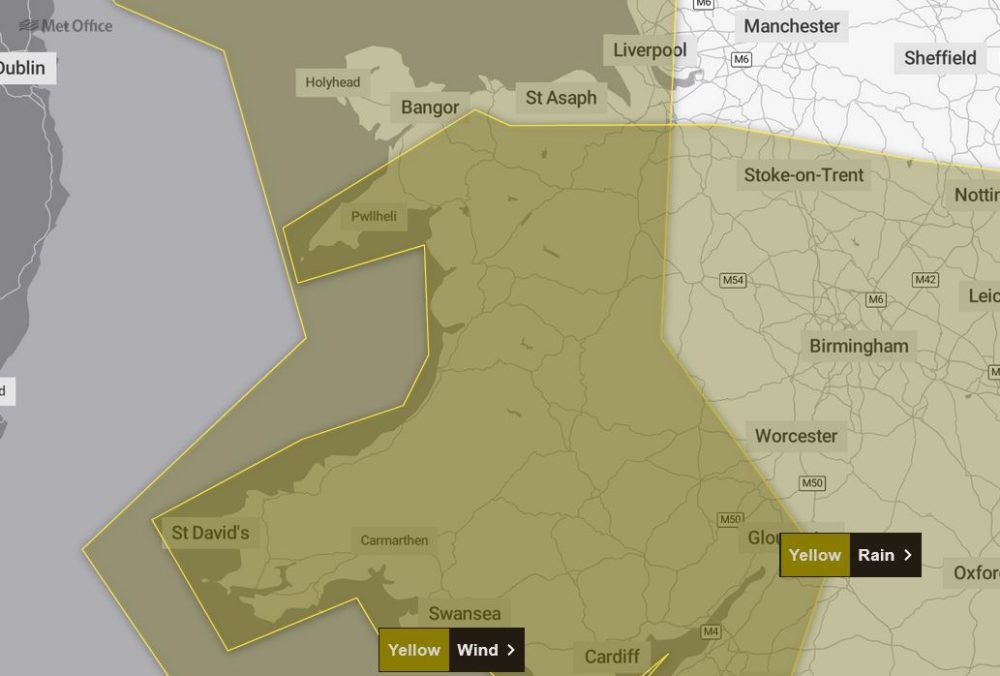
Up to 80mm of rainfall could be seen in parts Wales, with several amber and yellow weather warnings issued by the Met Office over Saturday and Sunday.
It comes after winds reached 100mph on Friday as the storm left one person dead, more than a million people without power and caused significant travel disruption across the UK.
Warning
A yellow warning has been listed for heavy rain that could bring “some disruption and flooding” in the West Midlands and much of Wales.
The warning runs between 6am and 11.59pm on Monday.
The Met Office said bus and rail services will likely be affected and spray and flooding on roads will probably increase journey times.
Flooding of “a few homes and businesses” is likely, as is “some interruption to power supplies and other services”.
Heavy rain means 20-40mm will probably fall “fairly widely” while higher ground could see 50-70mm.
Wind
On Sunday, a yellow wind warning covering Wales will be in place from 8am to 3pm, with 50 to 60mph gusts expected widely in the warning area.
A yellow rain warning covering southern and central Wales will also be in place from 8am on Sunday to 6am on Monday.
Some places could see up to 80mm of rainfall over the period from two separate spells of heavy rain and thundery showers, while 10 to 20mm should fall quite widely and 30 to 50mm could fall over high ground.
Flooding to homes and businesses could occur in the warning area, with power cuts and difficult driving conditions also possible.
There is also a “small chance” of fast flowing or deep floodwater causing danger to life, the Met Office has warned.
Met Office meteorologist Jonathan Vautrey said: “Looking at Sunday, it’s set to be a fairly fine start for a lot of areas – another ridge of high pressure building in to keep things fairly settled, with some sunny spells in there.
“The cloud, though, is going to be building as we see a low pressure system move into the South West. This will be bringing heavy rain in for south-west England and Wales from sort of mid-morning onwards, and then that will spread into Northern Ireland and northern England as we head later on into the afternoon.
“Winds will also be picking up with this feature. Certainly, it’s not going to be as strong as Storm Eowyn. However, because it’s coming in from the South West, it’s going to be actually more southern areas of England that are going to see the strongest wind gusts compared to what has mostly been further towards the north.”
Ice
A yellow ice warning covering mid-Wales will be in place from 3am to 10am.
“From daytime tomorrow onwards, the start of Saturday is quite a nice one for more central and southern areas of the UK,” Mr Vautrey said.
“There’s going to be a lot of sunshine around, relatively calm winds as a transient ridge of high pressure builds its way in, and so for a lot of people away from those still ongoing winds across northern Scotland, Saturday will generally be quite a reasonable day.”
Support our Nation today
For the price of a cup of coffee a month you can help us create an independent, not-for-profit, national news service for the people of Wales, by the people of Wales.


