


Report reveals causes of Storm Dennis flooding across areas of Rhondda Cynon Taf
Anthony Lewis, local democracy reporter
The causes of flooding in three more areas of Rhondda Cynon Taf during Storm Dennis have been revealed.
The latest section 19 flood reports from Rhondda Cynon Taf Council published on Tuesday, January 25, look at the Treforest, Glyntaff and Hawthorn and Taff’s Well areas.
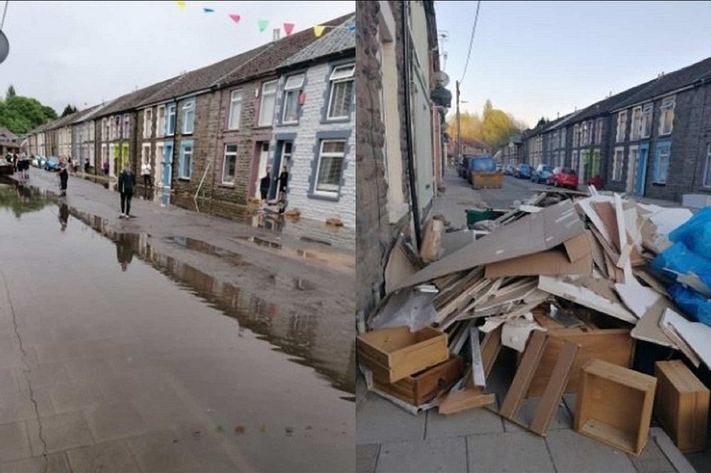
In Treforest, there was flooding to 50 properties in the area, including 43 houses, along with significant highway flooding.
The report said the primary source of flooding in Treforest was the overflowing of the River Taff following persistent and heavy rain.
Natural Resources Wales’ (NRW) river level gauge recorded the river to be almost four times higher than it usually would be, peaking at 5.32m.
Using NRW mapping, the impacted properties are identified as “medium and low risk” of flooding from the river.
Normal defences were in place but the water flowed over them during Storm Dennis.
Surface water
The investigation also identified that surface water accumulation on the highway contributed to the flooding and exacerbated existing river flooding.
The report for Glyntaff, Hawthorn and Rhydyfelin said 27 properties (including 23 houses) flooded and there was significant highway flooding.
The report said the primary source of this was the overflowing of the River Taff at several locations along its eastern and western embankments. NRW’s gauge recorded the river level to be almost four times higher than usual, also peaking at 5.32m.
NRW mapping identifies the impacted properties as “high risk” from main river flooding, while no formal flood defences are in place.
Investigations also identified that surface water accumulation to the highway contributed to the flooding, as drainage infrastructure was overwhelmed.
A manhole at Cardiff Road, associated to the Ilan Avenue culvert network, also surcharged.
And the report for Taff’s Well revealed that at least 36 properties, including 25 houses and 11 non-residential properties, flooded, along with significant highway flooding throughout the area.
River Taff
The report noted the primary source was again the overflowing of the River Taff. NRW’s gauge recorded the river level to be more than four times higher than its typical level – peaking at 5.49m.
NRW mapping identifies the impacted properties as “low risk” from main river flooding, with defences along the eastern embankment.
However, a section of the northern riverbank was identified as having no formal defence.
Along with accounts provided by residents, this information suggests the river initially overflowed at this location – allowing flood water to flow behind the formal defences towards Cardiff Road, the report said.
It also said surface water accumulation to the highway also caused flooding and exacerbated river flooding in the area.
Each report concluded it is unlikely that flooding from a similar event such as Storm Dennis could be prevented entirely, and the relevant authorities “satisfactorily carried out their functions in response to the flooding”.
However, they added that further preparation measures to have been proposed by all of the authorities involved.
In all three areas, the relevant risk management authority (RMA) in managing main river flooding is Natural Resources Wales, which the reports said has carried out analysis in order to understand the mechanism of flooding.
Flood risk
It has also commissioned a project to assess flood risk management options and has come up with recommendations to improve areas like the performance of the NRW flood warning service and its incident management response.
The council is the risk management authority for surface water flooding at all three locations and the reports said the council has carried out survey, jetting and cleaning works to infrastructure and has led on the development of a central control room to provide a comprehensive response in future flood events.
They said the council has engaged with NRW and Welsh Water over their responsibilities as RMAs, and worked with NRW to expand the property flood resistance project, offering expandable barriers to high risk properties.
Each report includes information from RCT flood risk management team inspections in the days after Storm Dennis, residents, the RCT public health team, NRW, Dwr Cymru Welsh Water, and technical reports.
The Flood and Water Management Act 2010 (Section 19) requires the lead local flood authority, RCT Council, to provide a factual account of what happened during major flooding events.
Following its investigation into 28 locations affected by Storm Dennis over February 15 and 16, 2020, the council is producing 19 reports in total. It has previously published a report for all of Rhondda Cynon Taf in July
2021 and further section 19 reports focusing on Pentre in July 2021, Cilfynydd in September 2021 and Treherbert in November 2021.

Support our Nation today
For the price of a cup of coffee a month you can help us create an independent, not-for-profit, national news service for the people of Wales, by the people of Wales.
Get more trusted Welsh news
Choose Nation.Cymru as a preferred source in Google News to see more of our journalism.


The Labour Party is a Disgrace to the valleys of wales kick all English party’s out of wales that’s the Tories Labour and all Brexit party’s it’s time for a new wales 🏴
There’s a lot of mention about the cause being high river levels, but a high river level is a consequence of rainfall rates around the time along with poor to non existent catchment land management. There’s no mention of those… I wonder why.